Temps stepped up yesterday, running into the mid 80s to around 90 degree for most of southern New England, away from the south coast.
After a few early morning showers/storm across eastern Mass, today, we’ll step up the temps and the humidity as dew points push toward 65-70 and highs head up to 90-95 just away from the coast. Along the immediate coast, a bit of a sea breeze waffles back and forth, keeping it cooler at the beaches. The storm risk is isolated this afternoon and this evening, with most locations staying hot and staying dry.


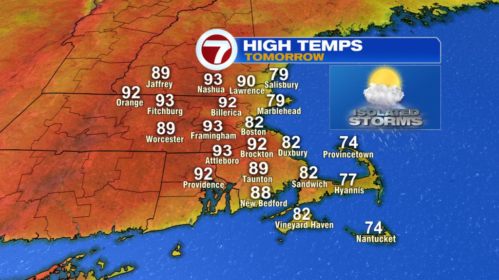
Tomorrow, it’ll be hot and humid again. Temps inland are into the lower 90s. At the coast, the onshore wind will be more pronounced, allowing for a cooler day there, in the 70s to low 80s. While a few scattered showers and storms fire up in the afternoon and evening, they’ll be hit or miss, so not all towns and cities will pick up on that. Dew points run near 70, so it’s a soupy, summery air mass through the evening. The highest risk for severe storms will be across the interior, especially western Mass and CT.

Heading into the weekend, the humidity will drop off as temps stay warm. We’ll head up to 85-90 Saturday and hang near 90 Sunday. Saturday has a sea breeze, Sunday does not. Overall, but days offer great pool or beach weather.


Early next week looks even more comfortable with temps in the 70s to mid 80s.