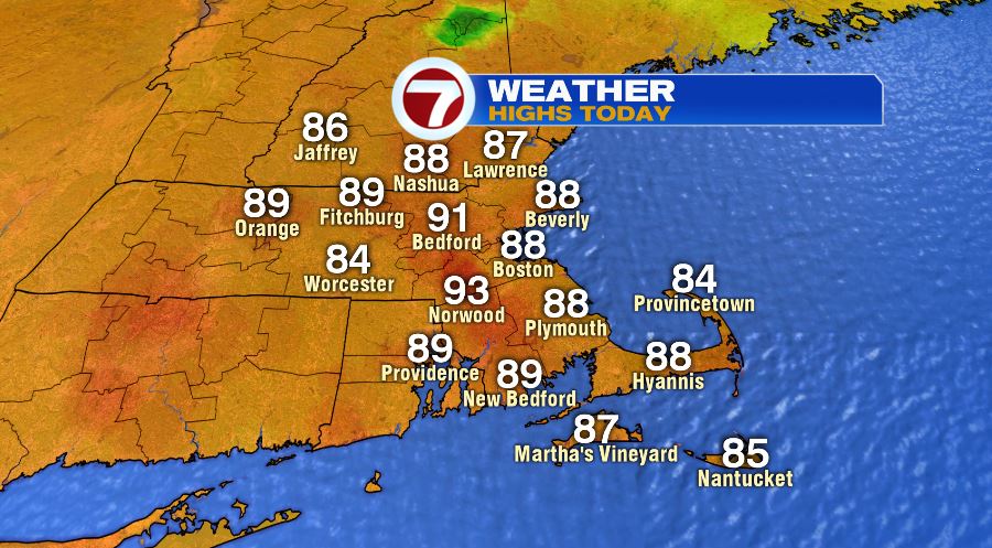
The past few days I have been barking on TV about afternoon temps reaching 90 but that “it will be a dry heat!” No different today, these were the high temps across the region…
and like the past few days, it was a dry heat, check out the dewpoints mid afternoon….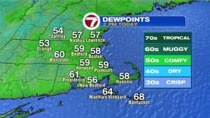
It’s not the humidity…it’s the heat! Well…..that’s going to change beginning tomorrow and lasting into early Saturday morning. The dewpoints will begin climbing tonight and you will feel it when you are on your Thursday morning run, whacking around the golf course, or tackling yard work. Dewpoint trend paints a better picture than my words…
The increase in dewpoints means three things
* Temps won;t be quite as hot…mid and upper 80s tomorrow
* It will likely feel more uncomfortable than today-yesterday
* The chance of rain begins to go up. Here is the risk for tomorrow…
Just a slight chance in the Worcester Hills but a higher chance across Vermont, New Hampshire and Maine. beaches likely stay dry tomorrow. A much high chance of showers, downpours and t-storms late tomorrow night and into Friday morning…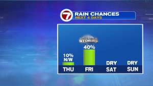
Friday isn’t completely lost to raindrops and lightning bolts as the highest chance of rain is before 10am (12pm on the Cape/Islands). Thankfully, this weather system moves out just in time for the weekend!
Dry both days. That 7-day is loaded with a fair amount of heat, some of which may be serious toward the middle and end of next week. July doing its thing.
Stay cool (and classy)
~JR