7Weather- We will have great weather Wednesday, and then cold air moves in to the end week. Temperatures reach into the 50s tomorrow, and then we wake up to wind chill values below zero Friday morning.
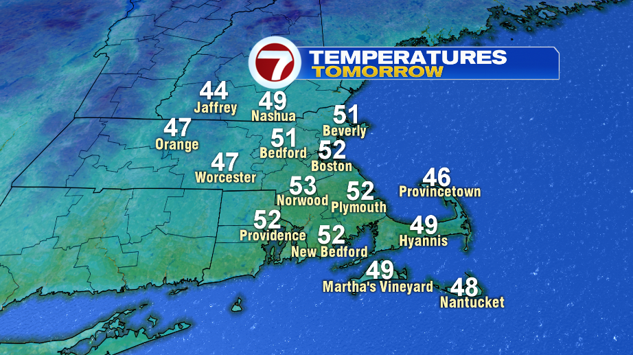
There will be some clouds around Wednesday morning, and then we clear up mid-morning. Highs reach into the mid and upper 40s in Worcester County and southern New Hampshire, and into the low 50s for the Merrimack Valley, Boston and southeast Massachusetts.
A low pressure moves through the region Wednesday night, bringing in rain with a few flurries mixed initially. There could be a lingering, spot shower early Thursday morning, and then skies gradually clear in the afternoon.

The wind really picks up behind this system Thursday evening. It will feel like the low and mid 20s at 5 PM.

Bitter blast! Wind chills will be between 3º to -10º Friday morning. The wind continues all day, meaning we don’t improve much in the afternoon. It will only feel like 5-10º.


The cold air is in place as a low pressure system moves in Saturday evening. It looks like it will be snowing for a few hours, giving us a few inches of accumulation. The snow then changes over to a mix overnight, and eventually it all becomes rain. The rain tapers off Sunday morning, and it will be windy and cold in the afternoon.
