It’s hard to believe another winter season is upon us and with that comes another attempt at trying to figure out what Mother Nature has in store for us.
If you recall (or don’t) last winter was cold. In fact, it was our coldest since 2013-2014. And like that previous winter, the cold last winter was relentless where December, January, and February all featured below normal temps, quite an accomplishment in our warming climate. But in terms of snowfall, last winter once again finished below normal (normal is 49”) with only 28”. That makes 8 of the last 10 winters with below normal snowfall. However, that 28” was more than the previous TWO winters combined! Even though it was our snowiest winter since ’21-22, Boston still didn’t have a single day where at least 6” of snow fell and that is a streak that continues to grow by the day:
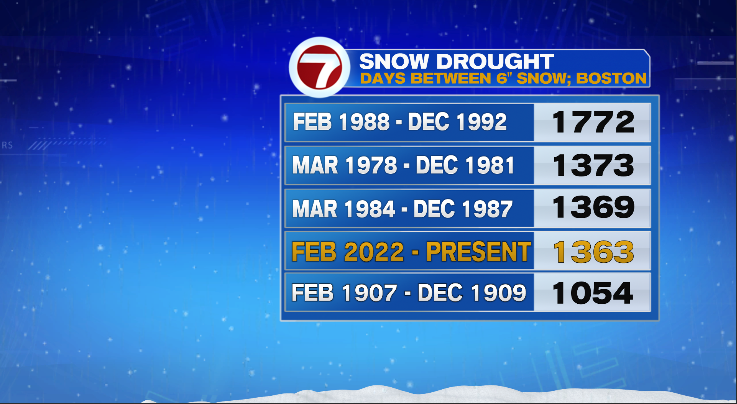
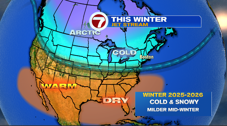
As of November 19th, we are in fourth place but we are less than two weeks away from securing second place on that list! Does our current streak end this winter?! In short, yes and probably in December. OK so the TL:DR outlook is this:
ENSO
Like all my other winter outlooks (9 of them), I like to check out the tropical Pacific Ocean and the El Nino-Southern Oscillation (ENSO) base state for the upcoming winter. When we look at the sea-surface temperature anomalies (SSTs), we see a patch of below normal surface water temps along (and either side) of the equator:
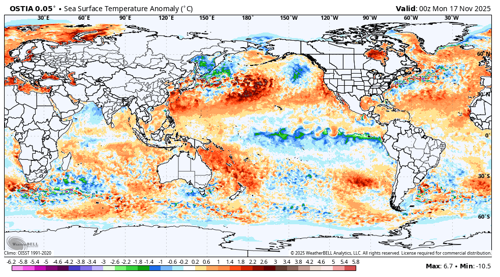
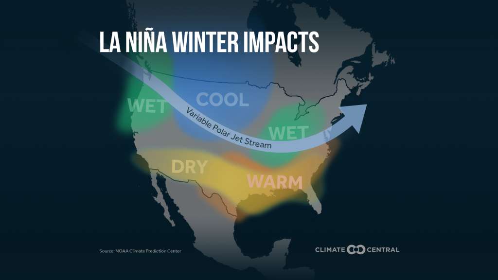
That is a signal for a La Nina. La Nina is the “sister” to El Nino and both of these ENSO states have an impact on global weather patterns both during summer and winter. Here is how a La Nina can affect global winter patterns:
Moving into and throughout the winter it appears a weak La Nina is likely. Some of the seasonal computer models suggest even ENSO “neutral” conditions:

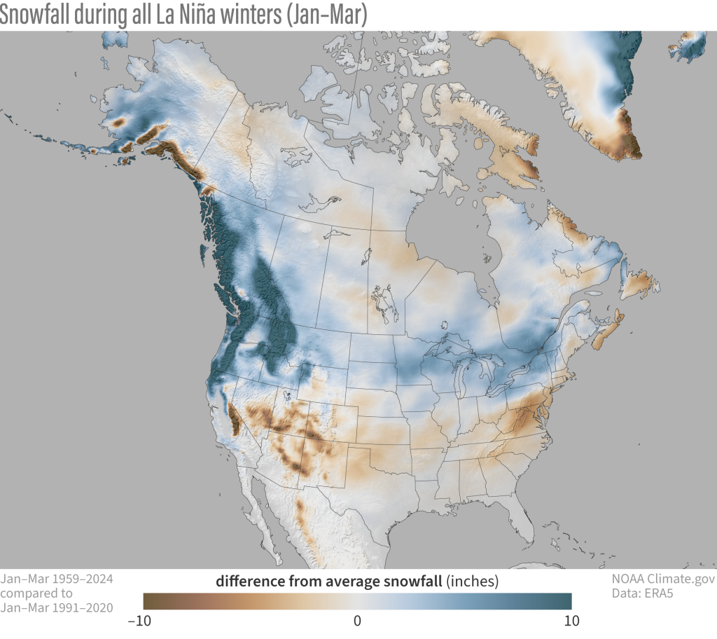
So I think we can safely say a weak La Nina (and possibly even ENSO “neutral”). If you recall from last year’s winter outlook, I talked about how a weak La Nina produces a different signal for snowfall here in New England versus a stronger La Nina. Here is the map showing a stronger La Nina footprint for snowfall:
And here is the weak La Nina footprint for snowfall:
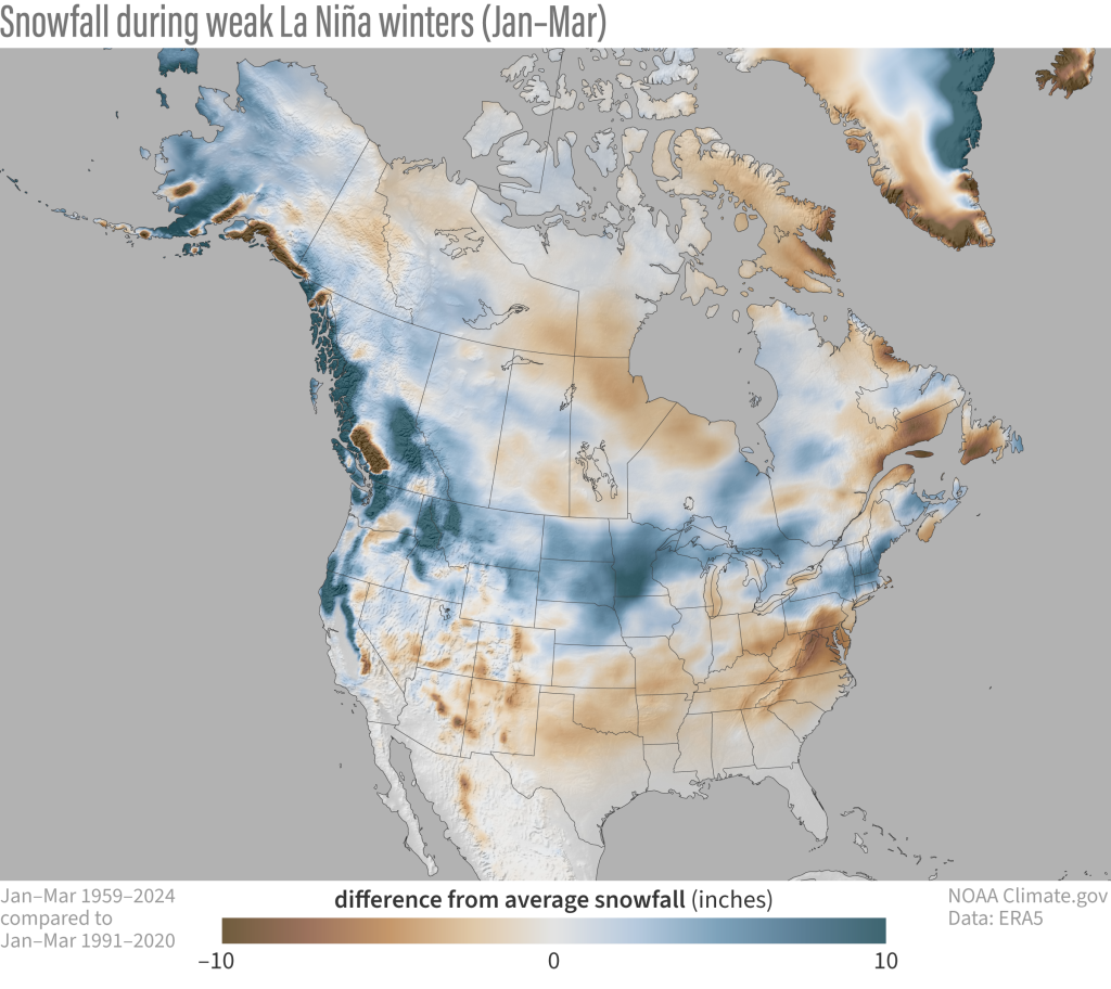
Notice the difference?! That shade of blue indicates above normal snowfall from the upper Midwest right into and throughout interior southern New England. Rejoice snow lovers.
Quasi-Biennial Oscillation (QBO)
Time for some sharing, while the goal of these winter outlooks is to deliver what I believe to be the upcoming winter pattern, I also hope to show you some of the levers, gears and springs that help to shape our weather patterns. Whether it be ENSO, NAO, AO, MJO, or the Polar Vortex (all discussed in previous winter outlooks) it has been fascinating to learn about these myself through the years and share them with you. So, this year’s gear effect on the atmosphere that I’d like to share with you is the quasi-biennial oscillation or QBO.

OK, so what is the QBO?!? Essentially, it is a belt of high altitude wind above the equator that flows around the planet. These high altitude winds either flow in the easterly direction or westerly direction, changing every 26 months or so. This graphic is loaded with great information regarding the QBO:
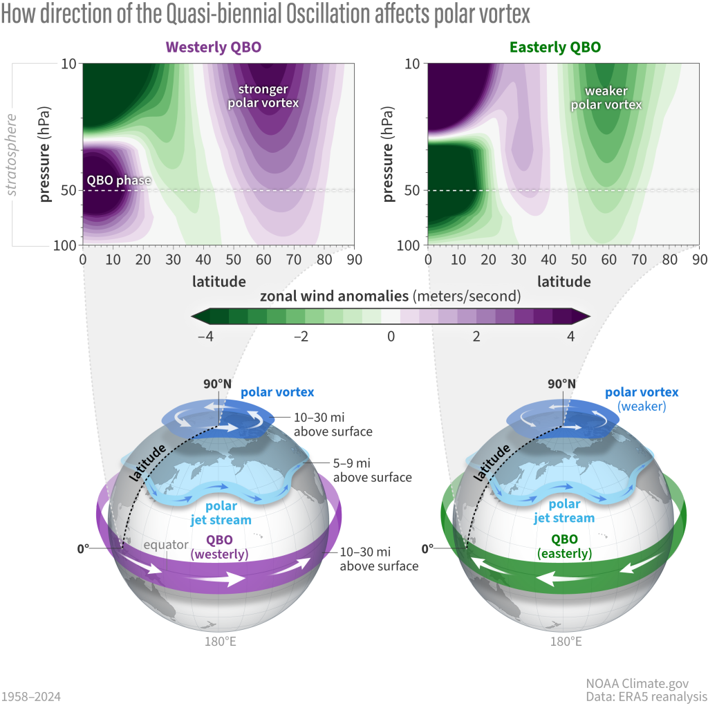
The takeaway is that depending on the direction (east/west) of the QBO, it can have an impact on the polar vortex as well as the jet stream. This winter the QBO will be in the easterly (negative) phase and that means an increased likelihood of sudden stratospheric warming events, which in turn weaken the polar vortex. A weaker polar vortex means cold air is more likely to escape the arctic regions and find its way into the United States. A weaker polar vortex can also suppress the storm track across the United States, often increasing the odds of big east coast snowstorms (provided ample cold air is present). Now, an easterly QBO doesn’t always produce cold and snowy winters here in southern New England but it means the chance is a bit higher this winter versus last winter when we had a westerly QBO. The other thing about easterly QBO winters is that they have a tendency to start fast (IE in December) and this one appears to be no different when looking at some of the December data.
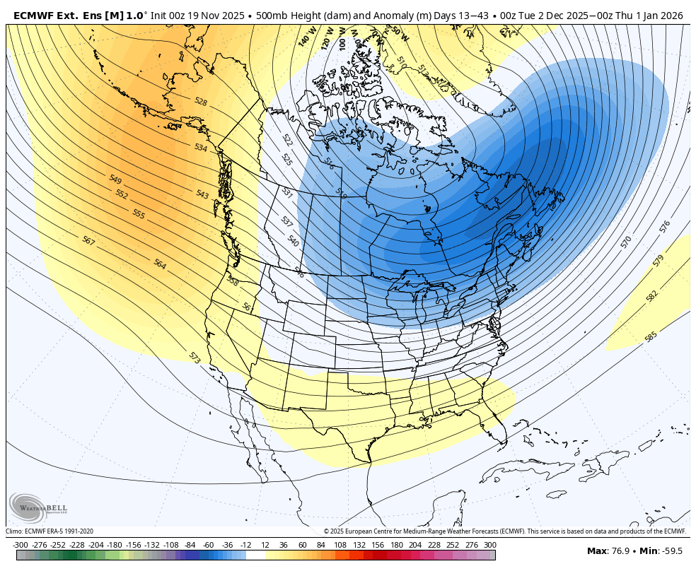
That map shows the general flow of the jet stream delivering cold air into the northern portion of the United States during the month of December. That would suggest any storms that head this way would have the opportunity to produce snow.
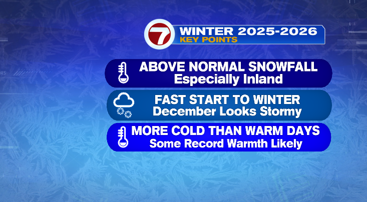
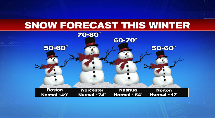
So based on a weak La Nina and the easterly QBO I’m leaning toward a winter that features a fair amount of cold and snow throughout the entire season. Of course, our planet is warmer now than 150 years ago so there will absolutely be warm stretches of weather and rainstorms instead of snowstorms but that’s usually the case in most winters (even 150 years ago). So with all that, here is my snowfall forecast for the region:
Let’s see how this outlook ages. As always, thanks for reading and enjoy the journey through winter!
;o)
~JR