Well, here we go again… kind of. I know that coming out of an historic storm like we experienced this past weekend leaves us all a little shaky hearing that “another nor’easter” is on the way. While both storms are in fact “nor’easters” due to the northeast wind component – these two storms will be very different. For this blog, let’s not focus on what happened last time (even though I do realize the cleanup and power restoration efforts are ONGOING), and just get into the details about what we’re expecting this time.
Timeline: The Wednesday morning commute looks to be unaffected – but the snow/rain will begin to move in around midday Wednesday. As it all revs up around 4pm, the Wednesday evening commute will certainly be affected. That means Wednesday may be the type of day where you can get to where you’re going, but you can’t get back. The worst of it all will be between around 4pm Wednesday and 4am Thursday, with the snow showers moving out early Thursday morning. I know I said I wouldn’t compare this storm to the last one, but the take-away “good news” here is that this storm will move through much more quickly than the last.
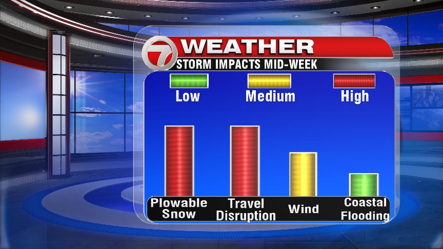
Impacts: This time around, snow tops the list – especially inland where a foot of snow is on the table (see snowfall map at the bottom of this post). These specific numbers are preliminary and subject to change. I know – I see the complaints on Twitter – “STOP changing the snow map!!” I get it… but don’t you want the freshest information? The latest update? We’re trying to keep on top of these events as best as we can, and as the weather can change quickly – so can the forecast. There will be a rain/snow line to track, but where exactly will that line be? That’s still a question and once the answer becomes clearer, the snowfall forecast may change.

We are still talking about strong wind with this next system, but not nearly as strong as the hurricane-force winds we experienced on Friday. This time around, wind gusts along the coastline will peak at around 50-55mph. Still strong enough to knock down branches/limbs & knock out power, but not to the extent that we saw on Friday.
Tides are lower this time around – so that takes the focus away from the threat of widespread coastal flooding this time. However, the ocean is still pretty churned up, and we still have an on-shore wind… so we will be watching for splashover and minor coastal flooding during the Thursday morning high tide (around 3:30am). It’s certainly worth noting that tides are expected to be about 2′ lower than the last time around.
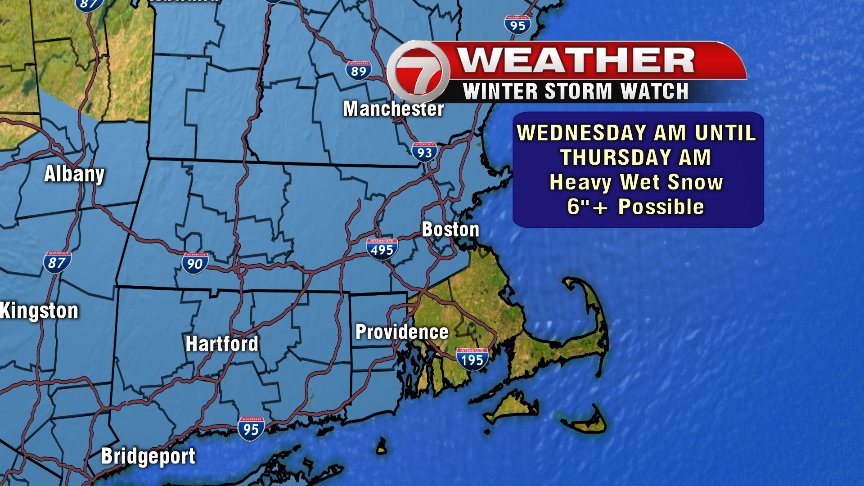
A Winter Storm Watch has been posted for much of the Bay State, with the exception of SE Mass. The areas under the watch are most likely to see the heavy, wet snow to the tune of 6″+. Again, the rain/snow line has been tricky to pin down – so the coverage area of this watch (and eventually a warning) may change with time.
For the current time, we still have a fairly nice and quiet day tomorrow to continue cleanup – and prep for the next round. As always, our team will always keep you posted with every update – on air, online, all over… even Twitter – but before you tweet at us, remember that we don’t control the weather. We just try to predict it as best as we can. Stay safe and warm. Spring is coming. – Breezy